Hammersmith & City Line Underground Stations – Facts, Trivia And Impressions

This post is part of my Randomly London v. The Tube Challenge. Get the latest about challenge updates here. Donate to Bowel Cancer UK here.

068 - Platforms at Baker Street Station
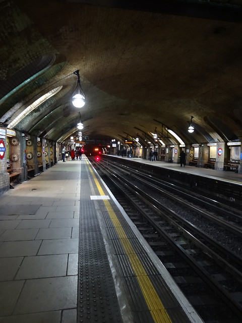
The best set of platforms on the entire network? I think so.

While the Hammersmith & City (H&C) line operates along the entire original section of the London Underground, it has only been shown as a separate line on the tube map since 1990. This means that it’s technically London’s newest tube line, although no new track or stations were built when the route was transferred from the Metropolitan line.

With the extension of the Circle line all the way to Hammersmith in 2009, the Hammersmith & City line no longer has any unique stations. Nevertheless, here are some photos, facts and my impressions of each of the 29 stations that currently make up the line:

Continue reading Hammersmith & City Line Underground Stations – Facts, Trivia And Impressions

Secrets of the Central Line By Geoff Marshall

Geoff Marshall returns to show you the secrets of the Central Line. For example do you know which station is the least used on the entire network? How about where you can find a Grade II listed bus shelter? Or a clock made up entirely of roundels? If you’re a tube nerd like myself I’m sure you’ll want to watch.

As a bonus you’ll learn a whole bunch of facts about escalators.

Finally, be sure to watch out for the secret echo room at Tottenham Court Road station. Last month Geoff did a very secret tube tour and showed it to me and others on tour. While he claims the sound effects don’t come across in the video, most of us on the tour thought this was one the highlights.

The only solution is for you to go experience it for yourself.

You can watch other videos in this series here:

You can also follow Geoff on twitter @geofftech and visit his website for more trivia.

Found via Londonist.com

Disused Tube Stations Mapped – London Underground’s Ghost Stations

Want to know where all of London’s disused/ghost Tube stations are located? Well just use the map above.

Now I wish I could take credit for it, but that honour goes to Dylan Maryk. He’s managed to scrape Wikipedia to give a location for every single station opened as part of the Underground but that is no longer in use.

For a full size version visit the site: http://www.dylanmaryk.com/stations/

Books About Ghost Stations:

1. Do Not Alight Here: Walking London’s Lost Underground and Railway Stations

2. London’s Disused Underground Stations

3. Haunted London Underground

New Geographically Accurate London Underground Map Shows Tube, Overground, DLR & Tramlink


Click to enlarge

Who doesn’t love the tube map? Yet as you no doubt already know the Harry Beck style map we use today, severely distorts geography to make it easier to read. This was a vast improved over previous designs (one of which you can still see just outside Temple station) in terms of readability.

However, when you’re walking the tube above ground you want something a little more accurate. The map above courtesy of the new Google Maps shows just how far stations like Amersham, Chesham & Epping are from central London. Gives a whole new perceptive to just how massive this whole walking project has been to date, and how much further I still have to go.

While this is by no means the first time the modern Tube Map has been given the geographically accurate treatment, this is the only one I know of that not only includes the Underground but also the DLR, Overground and Tramlink as well.

Found via Reddit.

Edit: As several people have pointed out to me on Twitter there are a few errors in the map. See if you can find them.

Lies on the London Underground – More Tube Secrets

Matt Parker and Tom Scott share a few secrets about where and when it’s faster to avoid signs at various stations and go against the flow of people. Nothing new for tube junkies.

They also given an example when it’s faster to walk above ground than trying to use the tube to get between certain stations. Something I’ve learned during many of my tube walks.

The London Underground lies for a few reasons, but the main ones are to control large crowds to avoid crushes of people and because of the design of the tube map for easier reading.

Found via Hacker News

The Secret Bits of the Northern Line By Geoff Marshall

Want to learn the secrets to a few of the Northern Line stations? Well Geoff Marshall, best known for his 23 attempts to break the world record for the fastest time traveling around the entire Tube network shares them in this video. Learn about the highest & lowest points on the underground, secret exits and the one station where you can leave only to arrive back where you started.

I’m sorry to see that I missed several of these when I did my Northern Line station visits a few months ago, perhaps an excuse to revisit them.

For more videos watch:

Found via Londonist.

Watch The Secrets Of The Victoria Line By Geoff Marshall

The video above is by Geoff Marshall a former world record holder of the Tube Challenge and also creator one of the best pages of tube trivia on the internet. It looks at the hidden side of the Victoria Line, something I may know a thing or two about as well. Enjoy!

To learn even more secrets read: Victoria Line Underground Stations – Facts, Trivia And Impressions

For more secrets watch:

Found via Londonist.com.

Bakerloo Line Walk – From Harrow & Wealdstone to Elephant & Castle

This post is part of my Randomly London v. The Tube Challenge. Get the latest about challenge updates here. Donate to Bowel Cancer UK here.

Red Telephone Box at Queen's Park
Red Telephone Box Seen at Queen’s Park

My overall impression of the Bakerloo line was not altogether favourable when I visited the stations, and initially, walking it does little to improve this. However, this is due as much to mistakes on my part as anything else.

I’m walking the Bakerloo line from Harrow & Wealdstone in far north-west London to Elephant & Castle in the south-east. It’s a cool, overcast day in October when I begin – the perfect weather for walking. Nevertheless, things begin to go wrong almost immediately.

A Shaky Beginning

First of all, I’m sleepy because I stayed out late at a work party the night before, which means I am slightly hungover as well. Far worse is the realisation that the internet on my phone is no longer working. For most experienced and/or prepared walkers this wouldn’t be a problem, but for me it is.

While I don’t have the best phone, it’s perfectly sufficient to run Google Maps. Within a very short period of time, I’ve become wholly dependent on it to navigate London’s streets. Why use an A to Z when you have a map with GPS right in your pocket?

Continue reading Bakerloo Line Walk – From Harrow & Wealdstone to Elephant & Castle

SUBCITY – Black & White London Underground Video

Given that SUBCITY starts at Queen’s Park (on the Bakerloo Line) I thought now would be a good time to post it. It features lot of great Black & White sequences at various famous London stations such Baker Street, Liverpool Street, Waterloo, King’s Cross and Farringdon among others. Watch for several good lingering and timelapse shots.

Found via reddit.

London Underground Tube Map Showing All Ghost Stations & Unbuilt Lines

The Map of the Underground that was and could have been
Click on map for full resolution version

I’m a huge fan of alternative Tube maps. And the one above may just be the most ambitious I’ve ever seen. Using TFL’s current London Underground map design, F. Dans has added in most ghost stations, unbuilt lines and disused extensions.

There are many interesting features, such as the District line out to Windsor (which did exist for a short time), the readdition of Aldwych and other Ghost stations and the addiiton of the proposed (but never fully built) Northern Heights extension.

However the one thing that really stands out to me, is that even with the addition of many proposed lines, few would serve South London. It remains a Tube wasteland, although one that is very well connected by rail (not seen on the map).

I first heard about the project from this thread on reddit where he’s seeking to add even more to the map. You can find out more about the project from his website and Flickr page.