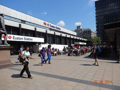
Euston is probably the ugliest mainline station in London, but at least it was a sunny day.
My second Overground outing was a somewhat ambitious trek from Euston all the way out to Watford Junction. I completed the 22.27 mile (35.84km) walk on a very sunny June 21st, 2014 in just under 7 hours.
A significant portion of line uses the same tracks as the Bakerloo line. This meant I ended up walking some of the same streets I had previously, although this time going in the opposite direction. In fact, until 1982, the Bakerloo line used to run all the way up to Watford Junction, which means this walk could also be considered a tube walk extension.
Here are just a few of the photos I took along the way. As always, I hope you enjoy!
The logo for Madrid’s Metro looks a little similar to the iconic London Underground Roundel. Image Source: Wikimedia Commons
After spending 4 days in sunny Madrid last week, I think got a good feel for the city (friendly people, great food and cheap beer) along with its metro system (Metro de Madrid). While it’s no secret that I’m a huge fan of the Tube, I think there are (at least) 5 ways Madrid’s Metro clearly beats the London Underground.
1. It’s Cheaper
While both have zone systems, pretty much anyway you cut it, Madrid is much cheaper than London. In Madrid, the basic cash fare for the Metro is €1.50 (£1.21), whereas in London, it’s £2.20 (€2.70) for a non-peak zone 1-2 journey paid with Oyster or a whopping £4.70 (€5.80) if the fare is paid in cash.
2. It Has More Lines
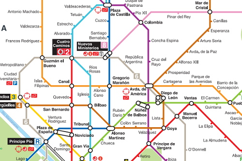
Some of Madrid’s Metro lines. Click for a complete map.
London boasts an impressive 11 underground lines (well 10 if we exclude the two-stop Waterloo & City line). However, Madrid has it’s own two-stop line, along with 12 others. This means that it beats London by 2 whole lines.
3. It Has More Stations
London Underground has 270 stations, which is pretty good until you learn that Madrid has 300. Moreover, until the recent financial crisis, Madrid was adding stations at rate that hasn’t been seen in London for over 60 years. According to Wikipedia (would be great if someone had a better source), Madrid’s Metro added 90 km (56 mi) of track and 80 new stations to the network between 2003 and 2007.
To put this in perspective, it’s roughly equivalent to the length and number of stations found on London’s entire Overground network.
4. It Has Far More Stations Per Capita
What’s even more impressive is that it has far more stations per capita than London. Madrid itself only has a population of 3.3 million compared to the roughly 8.2 million people who live in Greater London.
This means that Madrid has one station per 11,000 people, whereas London has 1 station per 30,370 people.
5. It’s Less Crowded
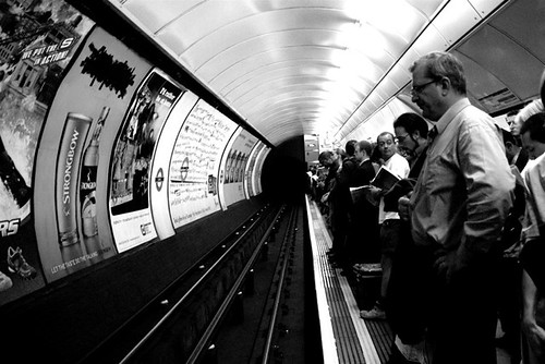
Normal day on the London Underground
Roughly 1.2 billion annual trips were taken on London Underground in 2013 compared to just 558 million taken on Madrid’s Metro. This means that, on average, only half the number of people use the Madrid Metro each day compared to the Underground. Great if you want to get a seat!
So while London still has an older network with significantly more miles of track, Madrid’s Metro stacks up pretty well on most head-to-head comparisons.
A Few Other Random Observations
For some reason the Madrid Metro is left-hand running, which is odd as Spaniards drive on the right. This may be due to the fact that residents of Madrid used to drive on the left until 1924.
The Madrid Metro turns 95 this year, which sounds old until you realise that the Underground is 56 years older.
The Madrid Metro doesn’t currently have a direct line from the City Centre to the main airport. Almost all passengers have to change to another line. While only the Piccadilly line goes to Heathrow, it does pass through central London.
I didn’t see any adverts in the trains themselves. Although you do get ads in the stations and on platforms…
And, most surprisingly, Line 2 of the Metro along with Sol station are both sponsored by Vodafone. And don’t think this can’t happen to London as it’s already being talked about.
These are just a few of the things I noticed in my rather limited interaction with Madrid’s Metro. If you know of anything I’ve missed, other differences and/or interesting features, please tell me about them in the comment section below:
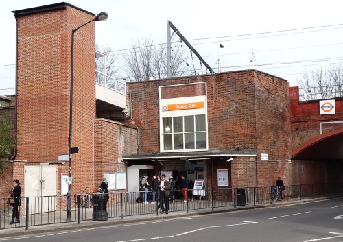
The somewhat randomly located Gospel Oak station was the starting point for my walk
On March 8th, 2014 I completed the first of my Overground & DLR walks by walking from Gospel Oak to Barking. Unlike my previous Tube walks there is no rhyme or reason to the order in which I’ll walk them. I started with Gospel Oak simply because it’s within walking distance of my flat.
Overall, the walk was just over 17 miles (27.4 km) and took a little over five and a half hours. This gave me an average walking speed of just over 3 miles per hour. Not terribly fast, but better than what I averaged walking the Tube. It was a beautiful sunny day so I took a few photos along the way. Hope you enjoy:
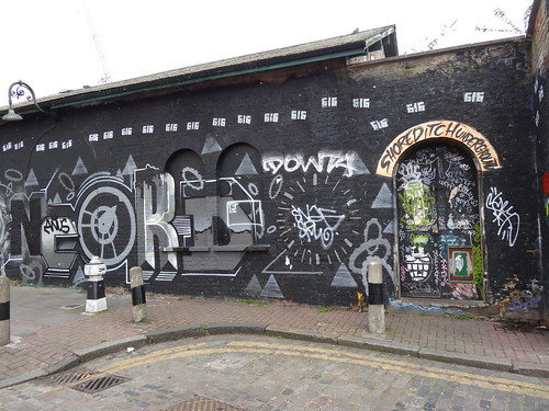
Former Shoreditch station was the end of the original East London Line
While I’ve only just announced my intention to walk the Overground & the DLR, I walked the former East London Line with Pete Stean from the Londoneer and Mandy Southgate from Emm in London last February as part of my original Tube challenge. They both wrote great summaries of the walk, which you can read by clicking the links above.
Stratford, the only place where all services & my walks will intersect
On August 24th 2013 I successfully completed my walk of the Tube network. In the interim I’ve been rather quiet about what my next major project would be. I’ve toyed with the idea of walking the Capital Ring and/or the London Loop.
While those are both projects I’d like to tackle at some point, I’ve decided to be wholly unoriginal and instead walk the Overground (that is the TFL Overground, not National Rail; at least for now) and the DLR.
I’ve no desire to repeat my long walks though London in the rain and cold. Thus, the project has no fixed order in which I’ll walk the lines nor a fixed end date to be completed by. I’m going to choose walks when I want to do them, rather than forcing myself to do them because I have to.
The format of the blog posts is also going to be slightly different. These days I find I have far too many projects to work on and far too little time to work on them. So instead of writing book chapter length posts, I’m just going to post some of the photos from each walk.
I hope you enjoy them just as much.
Finally, I’m going to keep raising money for Bowel Cancer UK. Please donate here.
What’s Happening With My Tube Posts?
I have no idea how closely you read this blog, but if you’re a particularly keen-eyed, long time reader you’ll have noticed that I still haven’t written up most of my tube walks (or even tube station visits).
Well there is still a plan to get these written up. The bad news is that it will take some time. In the meantime I hope you do enjoy the other posts on this site.
Geoff Marshall’s at it again with more secrets of the Underground, this time looking at the District Line. Want to know where you can find a swastika on the Tube? Where you can find a 1932 (pre-Beck) map? Where you can see two fake houses in one the most expensive areas of London? Go under a river at platform level? Or which station has two names?
The latest in the TUBE TUBE series, this one centres around a night out and how expensive it can be in London. Given the choice, I’d still choose to spend £100 here then go to Bruges.
This visualization in the video above builds upon the thesis research of Jay Gordon. It was sponsored by the MIT Transit Research Group and Transport for London.
From the YouTube Description:
This visualization merges all 16 million daily transactions made on London’s Oyster card with vehicle-location data from the city’s 8,500 buses to infer the travel histories of that day’s 3.1 million Oyster users. After inferring the times and locations of each bus boarding and alighting, bus and rail transactions are combined to reconstruct each cardholder’s daily travel history.
Each pixel represents an approximately 100-square-meter section of Greater London, and the brightness of each of the three RGB color components indicates the number of riders in one of three categories. Green indicates the number of passengers in the transit system, whether on a bus or in one of several rail modes. Blue indicates the presence of riders prior to their first transaction of the day or after their last: it is assumed that the location of a rider’s first or last transaction approximates their place of residence. Red indicates cardholders who are between transit trips, whether transferring, engaging in activities, or traveling outside the transit system.
By matching Oyster transaction records to data from the iBus vehicle-location system, buses are shown to traverse the street network at their observed speeds, and their brightness reflects the number of passengers on board. Rail customers tap their cards when entering or exiting stations, but their waiting times and choices of line and transfer location are not known (in this version). Rail passengers are therefore shown traveling in straight lines at constant speeds, interpolated between their entry and exit taps.